Riding a bike uses
to be a happy activity. If you do it in a park or a forest, then it
turns into a relaxed, quiet trip. The relation of bicycles with
environment has been deeply studied regarding the avoidance of
pollution and the replacement of motor vehicles. As you know, bike
lines constitute the specific paths for bikes. It would be ideal if
these points could be joint in a unique infrastructure.
It turn out that
this building already exist. Genk is a city in Belgium which has made
it possible. They were to build a bike line in a park, but faced a
problem: How to cross a lake. Engineers thought over it with the
intention of integrating it into nature. So, traditional bridges were
discarded. Finally, they came up with the following:
Every cyclist I know want to ride it. It is awesome, marvelous, cool, you name it. And above all, it represents the complete integration of bikes with environment. The optic effect makes as if those bikers were riding on the water, although it presents a little trick:
When
raining, the special pavement and the lateral guides evacuate the
water.
Donostia is one city
in the north of Spain. It has gone after making citizens lives
healthier for ages. Back in the 90s, the city started changing its
goal towards people and sustainable mobility. As a result,
pedestrianization was shyly used with the opposition of some
businesspersons and political opponents at the beginning. The first
group feared a reduction in sales, whereas the former made noise just
to try scratching some votes. Fortunately, sales in local businesses
increased in pedestrian areas since potential buyers had more time to
walk absentmindedly, hence to enjoy the short-noise, pleasant spaces.
These interventions have improved people life quality and showed
other cities the right path. Such actions were spread out
strategically to historical and tourist areas like the Concha beach
as time went by. In turn, satisfaction indicators boomed. Today,
local businesspersons demand strengthen pedestrianization to the
mayor conversely to what asked for at the end of the last century.
Regarding bicycles, Donostia has made efforts to build bike lines, increase the bike road network to more than 52 km, implement Dbizi (the local public bike sharing system), create the Bicycle Observatory, a bike registry, etc. The Bicycle Observatory (http://www.cristinaenea.eus, in Spanish and Basque) aims at promoting the bicycle use in the city by giving practical tips, rules and explaining the relation between bicycles-pedestrians / bicycles-cars to urban bikers and stakeholders. Moreover, it gives advice about what to do when your bike is stolen. And finally, it organizes courses and workshops to foster the bike use.
Pontevedra
is a city in the northwest of Spain. It has been internationally
recognized for its efforts in promoting healthy life among its
citizens. Others cities in the world copy its actions at urban
planning to improve life quality by the process in which if an
intervention works in one place, it is about to be successful in
another one. But how has it been acknowledged towards sustainable
mobility?
Miguel
Anxo Fernández Lores has been its mayor since 1999. At the begging,
he put his hands on his head as 14,000 cars passed along some streets
while much less neighbors lived on them. He had in mind ending with
this nonsense. Today, Pontevedra is one of the quiet cities in the
noisy Spain.
In
this time, he has transformed the city by following a simple and
powerful idea: Owing a car does not give you the right to occupy the
public space. This philosophy confronts to what has been the dominant
model in cities: Throwing out children and senior citizens from
streets because of cars. At the beginning pedestrianized all the
medieval center (300,000 squared meters). This allowed natives and
tourists enjoying so vast area. They realized people looking for a
place to park caused the most congestion, thus stopped cars crossing
the city and got rid of street parking. They incorporated other
actions like extending the car-free zone from the old city to the
18th- century area, substituted traffic lights by roundabouts and
traffic calming areas by reducing the speed limit to 30 km/h.
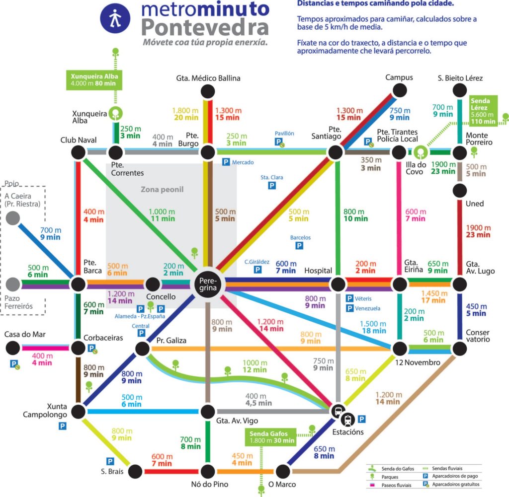
An interesting and copied idea was the launch of the Metrominuto. The Metrominuto is a map centered in the aesthetics of metros maps, which marks the pedestrian distances between the most important points of the city and the time it takes to travel them:
Metrominuto
Thanks
to this beneficial interventions nobody has died in car accident in
the city since 2009, whereas 30 people died from 1996 to 2006. CO2
emissions reduced 70%. Almost three-quarters of car journeys are made
on foot or by bike. Withholding planning permission for big shopping
centers protected small business. The works were exclusively financed
locally and received no aid from regional or central government.
To
sump up, motivated leaders with the unique target of benefit society
and a sustainable mobility vision is what cities need.
As I talked about, intermodality is the combination of two or more ways of transport. The first post dealt with bikes and buses, whereas I am going to enhance your knowledge on the subject of the sum bikes plus trains today.
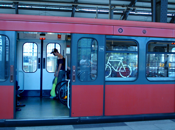
Lots of people use the conjoint ways of transport in an everyday routine to go to work or study. This intermodality is well-developed in those countries which enjoy a vast railroad which in turn constitutes a serious competitor against cars. Moreover, the train lines which go to parks fill up on weekends. One can see two main modalities in this intermodality. The first one appears when bikes can get into the train with no specific area where to put them. It is like if you go inside the coach and lock your bike wherever you can. This fact could make the trip uncomfortable to some passengers, but the point here is the authorities tactlessness as they have not considered the bikers necessities.
In comparison, the ideal alternative is to dedicate specific carriages for bikes. Usually the first or the last coach is highlighted with bicycle pictures on the bodywork or the windows, so that everybody understand it as the place to put the bikes. In the next photo, you can see how it works. Notice the division in bikes-area and people-area. This way makes it easier for riders to seat close to their bikes.
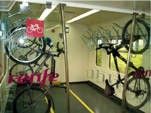
Nevertheless, there is another way to transport bikes. In the previous picture, bikes were put in horizontal as they move on the road. The next option is to hang them to gain extra capacity (see the next photo). Again, a zone for bikers is needed, limited by the two transparent panels. The central corridor also allows the engine driver to move freely.
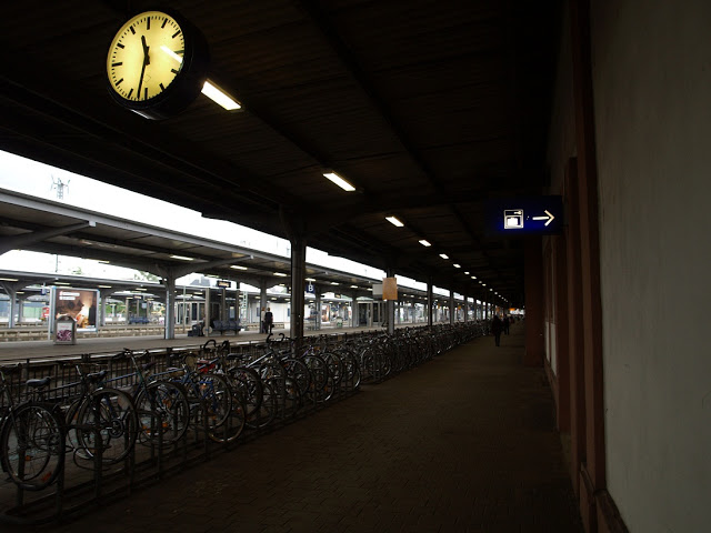
In addition, if the train station has a good and large parking bike like in the next picture, the use of train by riders is increased.